North-eastern Lake Ontario
Background: Ship losses, causes and claims
Scope
For the focus of potential further study, a timeframe of approximately 1850 to 1920 covers the transition from sail to steam; merchant (commercial) ships may take priority over naval and recreational craft; a geographic area from 76° to 78° W and from 43° 20' to 44° 30' N encompasses the Eastern part of Lake Ontario [Note 1], including access to Bay of Quinte ports, Kingston and the entrance to the St Lawrence river, together with the American ports of Oswego, Fairhaven and Sodus Bay. The navigational season (relatively ice free) extends from approximately early April to late December. Ship losses may include classifications of final or, more rarely, incidents requiring major rebuilds. Causes may include accidents, collisions and allisions [Note 2], navigational errors, meteorological extremes, errors in seamanship, fire and other circumstances leading to sinking, foundering, grounding, etc with associated material damage and potential loss of life or injury.
|
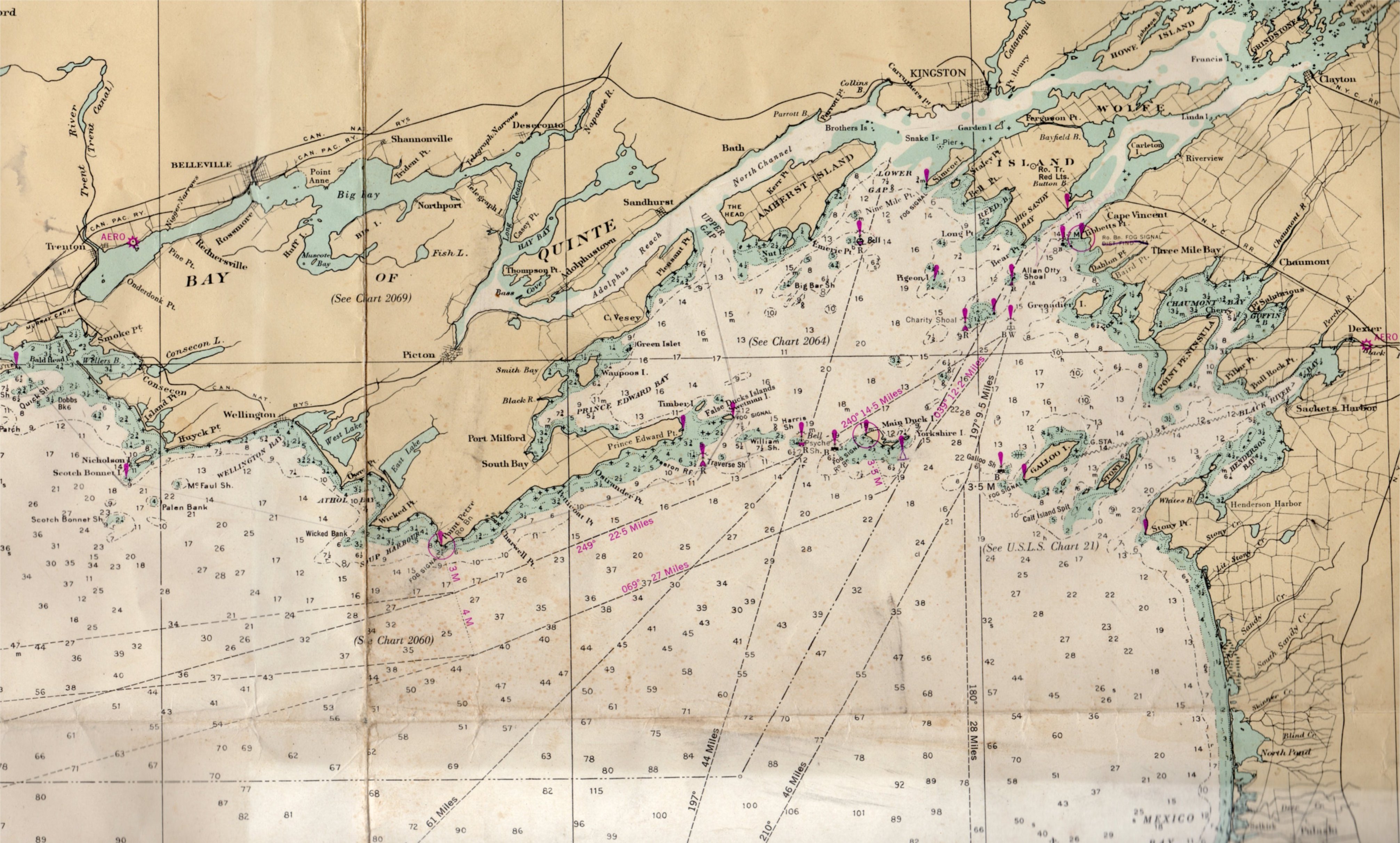
Image 1: Mariner's chart, Canadian Hydrographic Service, |
Geography
The Northern shore may be described as complex. The mainland of Canada, from Trenton and Belleville to Kingston is bordered by relatively narrow and shoal bays and reaches, delimited southward by Prince Edward County, Amherst, Wolfe and Howe Islands. The southern coast of Prince Edward County includes numerous bays, headlands (points) and shoals, and is extended, a little south of east, by the Duck-Galloo chain (geologically a ridge) to the American shore at Stoney Point. This chain, and the waters to its north, contain numerous shoals requiring navigational and/or local knowledge to permit safe passage. There is a somewhat narrow passage, the St Lawrence Channel, with depths from 100 to 160 feet (30-50 m), permitting larger ships to pass between Main Duck and Galloo Islands to the St Lawrence river. To the south, the waters are open, relatively deep and obstruction free.
Magnetic variation and anomalies
Magnetic variation (the angular difference between true north and a compass needle pointing to the magnetic north pole), which varies over time, has been understood and documented for many centuries. It is normally fairly constant in open oceans, but can differ in regions of shoal water where magnetic iron ore or rock strata containing iron exist in the seabed under a ship. The area under study here is somewhat prone to this phenomenon. However, the Department of Fisheries and Oceans (Canada) in Sailing Directions, Great Lakes, Vol I only draws mariners' attention to the area just outside Kingston harbour (a six-mile stretch of water between Melville Shoal and Spit Point), and an area close to Tibbetts Point light at the entrance to the St. Lawrence river.
The Charity Shoal, adjacent to the St Lawrence Channel, saw the grounding of the SS Rosedale on 5 December 1897, successfully recovered. The Shoal had been previously mapped as a bedrock shoal in hydrographic charts, but in 1999 was identified as an anomalous crater-like feature in bathymetric mapping compiled by the Canadian Hydrographic Service and the US National Oceanic and Atmospheric Administration. The improved resolution of the 1999 mapping clearly showed a 1200-1400 m annular bedrock ridge with a central crater-like basin. Holcombe et al. (2001) [Note 3] described the morphology and considered the origin through several geological models, including a glacially-eroded kettle hole, a karstic sink hole, a volcanic intrusive and a meteorite impact crater. A meteorite impact origin was the favoured hypothesis, as it was deemed most consistent with the crater morphology and a subtle negative magnetic anomaly (~250 nT) observed in regional aeromagnetic data. The total field magnetic anomaly is large by geological research standards (> 1500 nT), and could give rise to a compass variation of several degrees in the very immediate vicinity [Note 4]. Charity Shoal was marked by a lighted buoy in 1900, and a lighthouse in 1935.
|
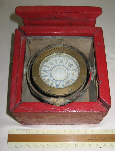
Image 2. Compass, circa 1880 (Morrash |
The mariner's compass
In the late 19th century, for smaller schooners and other vessels trading in this area (somewhat comparable with inshore waters), a compass was seen as necessary, but economy often dictated smaller sizes. Such a compass was often the property of the captain/master, rather than a fixture on the ship. The illustration shows a typical gimballed compass of circa 1880, with a 2.5" (6.4 cm) card, graduated to 64 points (or 5 5/8°). At this period, with any sort of sea state other than relative calm, it was probably impossible for the average helmsman to steer a ship on a truly accurate course, and some vessels had reputations of being "crank" or extremely difficult to steer. Sailing vessels would most often use the wind to best advantage, and wear or tack only to avoid headlands or shoals, or at harbour entrances (particularly if a tug was not available.) The advent of the steamer, able to maintain speed in conditions of low visibility, increased the importance of the compass; for sailing vessels fog was not often accompanied by strong breezes, and squalls with low visibility lasting for more than short durations were somewhat rare during the normal navigation season. Contemporary accounts, including log entries where available, rarely record a compass course steered.
|
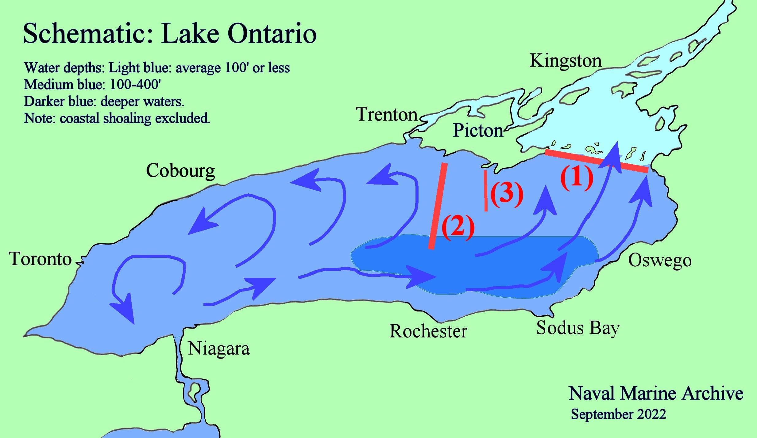
Image 3: Lake Ontario, bathymetry, ridges, flow (generic) Click for enlargement. |
Bathymetry and currents
As an overview, Lake Ontario from a bathymetric perspective (see image 3), has its deepest waters, a little over 800 feet, towards the South shore and slightly East of its centre. It is categorized by a major ridge [(1) in image 3] commonly referred to as the 'Duck-Galloo ridge' that represents a major shoaling of the lake waters accompanied by further restrictions in the form of islets, from West to East Timber Island, False Duck and Swetman, William and Harris shoals, Main Duck and Yorkshire Islands, Galloo shoal and Island, Calf Island spit and Stoney Island.
A second ridge [(2) in the image], often named the Scotch Bonnet ridge, extends slightly west of south from the shore of Prince Edward county to the western end of the deepest waters; it corresponds to the start of a significant counter-clockwise turn of lake currents. A third ridge, the 'Point Petre ridge' [(3) in the image] also marks a potential upwelling.
The lake's inflow and outflow, while significant, account generally for little current. However, upon reaching the "deepest gap" – the entrance to the St Lawrence channel in the Duck-Galloo ridge – the outflow represents a potential current of approximately 0.3 knots or 0.5 kph at the surface, accompanied by a return flow at deeper depths (which include seasonal variations.)
Lake Ontario has no measurable tides; a theoretical tide of less than 1mm can however be calculated. There is however a natural phenomenon known as a seiche, caused by the meteorological effects of wind and atmospheric pressure variations, which has been well documented, demonstrating temporary, sometimes damaging, increases in inshore water depths of up to two or even three feet. The phenomenon is accompanied by a lowering of water levels in other parts of the lake, and always reverses itself back to previous equilibrium, often quite rapidly. We are unaware of any seiche-caused casualties, although there are a few anecdotal reports of minor damage to smaller recreational boats.
|
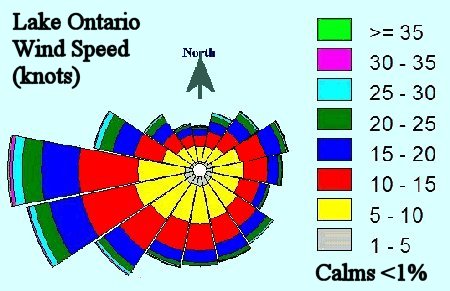
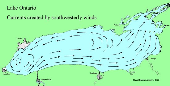
Image 4: Winds, direction, speed, frequency (generic). |
Winds, waves and wind-driven currents.
The prevailing winds over Lake Ontario are westerly to sou'westerly; the strongest winds tend to occur in November and December.
More importantly, for this overview of potential shipping casualties, wind-driven surface currents must be taken into account. The average wind velocities over the lake are about 15 miles (24 km) per hour. The relation between winds and surface currents is that currents travel at less than 35° to the right of the mean direction, and current velocities are approximately 3 percent of mean wind velocity. [Note 5]. Such wind-driven currents may be expected to increase water levels at the down-wind end of the lake, the increase being normally insignificant but maybe up to several inches in cases of sustained periods of strong, unidirectional winds.
For wave heights, the oceanographic model (see Oceanography and seamanship, William van Dorn) has a potential to create, and with a fetch (the distance of clear wind over water) the length of the lake, wave heights up to ten feet (3 metres) under sustained gale-force (34–40 knots or 62–74 kph) conditions. However, a word of caution is required: given that the lake is 'small' by hydrodynamic standards and that its depth is limited and irregular, upwelling and wave reflection will occur, with potentially major divergences from standard oceanic models. Specifically, irregular and confused sea states may be expected in proximity to shorelines and shoals.
|
Image 5: Wind patterns - south-westerly. |
Causes of ship losses, wrecks and incidents
Causes can be classified, in approximate order of frequency, as strandings and groundings; fires (which increased enormously with the introduction of steam vessels); collisions with other vessels (occasionally with floating or submerged wreckage); allisions with harbour structures, docks, bridges, etc.; foundering due to overload or shifting cargo, or to water ingress particularly in open barges or from badly secured hatch covers; state of repair of the vessel (often old age and/or lack of owner finances); business profit decision to risk a late season voyage; inexperience by master, particularly in weather forecasting; crew inexperience, mistakes and incompetence. There are very few reports of vessels being scuttled in harbour (and pumped out later) to prevent other forms of damage during storms and surges; there are also a few suggestions of baratry (purposeful loss of a ship for insurance purposes) but none that we have found that were successfully prosecuted in court. Statistically, late season (November, December) shows an increase in losses and accidents. Geographically the western and southern shores of Prince Edward County with the extension of the Duck-Galloo ridge demonstrates an above average density of losses for at least two reasons: firstly it was a high trading/traffic area, and secondly is is "down-wind" in the lake's prevailing wind patterns.
This list of causes would be incomplete without mentioning (outside the scope of this project) a few vessels that were scuttled to avoid capture by a naval opponent (War of 1812), and a few that were sunk by gunfire during the "rum running" days of prohibition.
Diligent research, often lengthy and requiring painstaking effort together with expertise in historical shipping and seamanship is required to arrive at logical, trustworthy explanations for these losses. In Canadian waters from Presqu'ile to the Upper Gap including the Duck-Galloo ridge (thus not including the Kingston area), we have documented twenty-five wrecksites, a further fourteen losses where wrecks may potentially be found, and more than twenty incidents reporting breaking-up that is unlikely to leave recognizable archaeological vestiges of a wreck. Our research continues. As a point of comparison, the proposed National Marine Sanctuary (all U.S. waters from twenty miles west of Sodus Bay to Cape Vincent) documents twenty-two (possibly revised to forty-three) known wreck sites, with a further sixty-six (possibly revised to twenty-four, plus three aircraft) "potential shipwrecks, based on historical records." [Note 6].
Some claims
After Charles Berlitz's The Bermuda Triangle was published in 1974 including a UFO reference to "temporary magnetic vortex", it became popular to invent pseudo- and non-scientific mystiques to sell to a gullible public thirsty for tales of death, disappearance and destruction. Lake Ontario was not immune to this trend, leading to Jay Gourley's The Great Lakes triangle, (Fawcett Publications, 1977) which is heavy on aviation and light on Lake Ontario. This in turn inspired Hugh F. Cochrane – the dust jacket describes him as "a free-lance writer with years of experience with UFO's and psychic phenomena" – who in his Gateway to oblivion : the Great Lakes' Bermuda triangle, (Toronto, Doubleday, 1980) coined the phrase "the Marysburgh vortex".
Marysburgh, in Prince Edward County, a 19th century Loyalist settlement bustling with shipbuilders, fishermen, farmers and traders, instantly became the nominative home of a swirling mass of gravitational and magnetic forces devouring ships and sailors (plus a few aeroplanes en passant.) Browsing through the book, we find (with a few editorial comments added):
- p. 3 : ... Marysburgh Vortex. This vortex, like the famed Bermuda Triangle, is a swathe of water in the eastern end of the lake [Ontario] that has a long history of bizarre circumstances that have caused the loss of numerous ships and their crews.
- p. 6 : They (crew of the Bavaria) had all mysteriously vanished as if whisked from the face of the earth. They were victims of the Marysburgh Vortex. [For a more rational explanation, see the details of the contemporary enquiry into her loss, particularly the testimony of Matthew Ferguson. Ed.]
- p. 8 : ... 1883, the vessel Quinlan ... direct line across the lake, one that would take her right through the middle of the Marysburgh Vortex. [In fact, the Quinlan was stranded on Poplar Bar, Dec 3 1882. Her crew was saved, salvage efforts in the spring failed, and she broke up over the years a total loss. Ed.]
- p. 11 : Throughout the history of the Bermuda Triangle and the Marysburgh Vortex, next to nothing has been done to initiate a thorough study of the phenomena encoutered here. [Hardly surprising: until these regional "histories" were invented, respectively in 1974 and 1980, nobody had heard of them, let alone studied them – neither 'thoroughly' nor anecdotally. Ed.]
- p. 13 : [schooner Picton] ... as she sailed towards the Marysburgh Vortex. ... One minute the Picton was there and the next she was gone... (p. 15) In an effort to provide a solution to this mystery ... the Marysburgh Vortex harbors a doorway into another dimension, an invisible gateway into some realm outside our reality. [See contemporary reports, nothing mysterious, crew errors during bad weather. Ed.]
- p. 19 : In the area of the Marysburgh Vortex, the shores of Lake Ontario narrow in toward the St. Lawrence river, creating a funnel-like enclosure. ... This area also takes the deepest point in the lake -- an icy well of blackness almost 850 feet deep, from which nothing returns. [The deepest point at 802 feet (244 m.) is more than 100 k. from the St Lawrence Channel Ed.]
- p. 21 : Along the way they had to pass right through the Marysburgh Vortex. The Protostatis never reached the sea. [Patently incorrect: the Protostatis went aground twice, the crew deserted in between the two groundings, insurance and government intervened and this old WWII Liberty ship was broken up in Valencia, Spain, July 1966. Ed.]
- p. 24, 31, 33, 46, all similar: "through the Marysburgh Vortex" ... never made it, had a fire on board, ...
... and finally ...
- p. 160 : Cochrane attempts to tie into the Marysburgh Vortex a mixture of Russian scientists, ultrasonic sounds and the Edmond Fitzgerald lost in Lake Superior.
This notion of a "vortex" has been picked up by Cheryl MacDonald in Shipwrecks of the Great Lakes : tales of courage and cowardice and by Janet Kellough Legendary Guide to Prince Edward County (not outrageous); more recently, during Covid, by Max Hartshorn of Global News ‘Strange things out there’: Inside Lake Ontario’s ‘Bermuda Triangle’; Paranormal Studies & Inquiry Canada The Marysburgh Vortex – A Primer; The Scuba News Shipwreck Diving in Lake Ontario’s Own Bermuda Triangle which states "Lake Ontario has its own hungry vortex of doom"; and the mystery of the Marysburgh Vortex, where "Shawn" starts by stating: "Every year at Halloween I do posts about..."
That these claims can occasionally be considered as "non-fiction" by some readers is most unfortunate.
Notes
1. [Back...] Lake Ontario in numbers: The lake is 245' (74 m) above sea level, average depth 283' (86 m), maximum depth 802' (244 m), catchment area 24,720 sq mi (64,000 sq km), flushing time about six years. The lake is 193 miles (311 km) long, 53 miles (85 km) wide and has 712 miles (1,146 km), including islands, of shoreline; total surface area of about 7,340 square miles (19,009 sq km), volume 1,639,000,000 cubic m. (1 cu m = 1 metric tonne.)
2. [Back...] A collision is with a moving object - here another ship, floating debris or wreckage. An allision is with a stationary object – harbour wall, dock or other fixed object – but can include a ship at anchor or moored in a harbour. From allidere, fourth century Latin, to strike against something or to be shipwrecked, whereas collision is from collidere, to strike together. Ref: Oxford English Dictionary, and Lloyd's insurance terms based on Admiralty Law.
3. [Back...] T.L. Holcombe, J.S. Warren, D.F. Reid, W.T. Virden, and D.L. Divins, 2001, "Small Rimmed Depression in Lake Ontario: An Impact Crater?", Journal of Great Lakes Research, 27(4): 510-517, 2001. Troy L. Holcombe, Scott Youngblut, Niall Slowey, "Charity Shoal crater, Lake Ontario, revealed by multibeam bathymetry" Geo-Marine Letters August 2013, Volume 33, Issue 4, pp 245-252. For a fuller analysis, see Charles O’Dale, "Charity Shoal, Lake Ontario, Canada".
4. [Back...] Magnetic influence decreases with the cube of the distance from the source, i.e. double the distance, the force is eight times less. Magnetic field strength (flux density) is measured in teslas (T); the unit nT used here is a nanotesla, or one billionth of a tesla (0.000 000 001T, or 1 x 10⁻⁹T). To put this in perspective, a hospital MRI machine produces about ten billion nT, the core of a loudspeaker magnet about one billion nT, and the average natural magnetic field over Lake Ontario is approximately 600,000 nT.
5. [Back...] "The average wind velocities observed over the lake at a height of 4 meters were about 15 miles (24 km) per hour. The empirical relation between winds and surface currents observed by previous investigators is that currents travel approximately 45° to the right of the mean direction, and current velocities are approximately 2 percent of mean wind velocity. Our data show surface currents in Lake Ontario to flow approximately 35° to the right of the mean wind direction and current velocities slightly less than 3 percent of the wind consideration of the data above, it should be pointed out that the so-called "surface" current meter was approximately 10 meters below the surface, and interpolation of the observed data suggests that surface velocities are higher than 2 percent, possibly 3 percent of the wind velocity, and that current directions at the surface are less than 35° to the right of the mean wind direction. These differences from previous observations by other researchers on various lakes can probably be explained by the shape of the lake basin, the placement of the current meters, and the fact that the long axis of the Lake is nearly aligned with the mean wind direction." Lake Ontario Environmental Summary 1965, revised 1973, US EPA, PA-902/9-73-002.
6. [Back...] There are some conflicting numbers, possibly an update or refinement, in NOAA mapping of wrecksites. See annotated charts.