Glenora ferries.
The Danforth Road entered Prince Edward County from Dorland's Point by the ferry at Stone Mills. This was the second stop on the stage run from Kingston to Toronto.
Willis Metcalfe noted in 1968 that "very little historical data is available" from the Ontario Department of Highways since 1936 when they assumed responsibility for Highway 33 from Trenton to Kingston. Some details were provided by Captain J.A. Haylock – senior ferry captain.
Prince Edward
For early, detailed history and origins, see early history.
As far as can be determined, the first known operator of a regular ferry was Joe Thurston, about 1880. Then J. C. Wilson operated the ferry while he ran the mill (Stewart Wilson bought the mill properties ca 1848; with James C. Wilson he built a third mill in 1877. The name Glenora is said to come from one of James' daughters, possibly named after nearby Glen Island). John Green, who was the foreman in the iron foundry behind the mills, owned and operated – or his son Jim Green was operator – the ferry, a side-wheeler propelled by a two-horse treadmill during the 1890's. He also bought the stage ferry hotel, a resting point for passengers on the stage run in earlier times, but by then it was no longer in use as a hotel.
For a while when the horse-propelled boat became obsolete, Glenora was without a ferry but there was enough steam traffic on the lake that it was not missed.
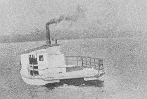
M/V Qunte, circa 1945
In 1905, a centre-paddle gas engine driven ferry was put into service by William Powless sponsored by the Picton Board of Trade. This vessel was taken over by Hugh McWilliams in 1918, and the engine changed to steam driven; Theodore Fraser took over in 1921.
The Picton Gazette reported on 22 July 1923 that: "The Glenora Ferry has changed hands and will be run under new management in the future. Mr Harold Hudgin of Picton being the new proprietor, and his father, Capt. John Hudgin, will be in command. Since taking over the boat, a first class marine engine has been installed in same, a small dwelling has been erected next to the dock for living quarters and in future, a real live ferry service will be given by Mr Hudgin. And from now on, residents of Adolphustown will be able to visit Picton on Saturday nights to do their trading, attend the Regent Theatre and have a general good time as the ferry will run until 11 p.m. on Saturdays."
Other reports that same year suggest that Charles and Albert Francis "bought the ferry" (or perhaps were associated with Harold Hudgin) and replaced the existing vessel with a propeller; Harold Hudgin continued to operate the ferry prior to it being bought by Robert McLeod in 1924.
In 1928 Robert "Bob" McLeod put the Nahomis into service. This ferry, wooden built, was driven by a Fairbanks-Morse diesel engine (later replaced by gas) with a screw at either end.
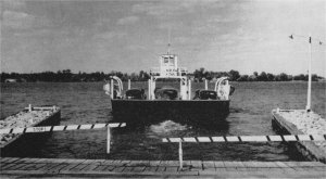
M/V Quinte Loyalist
Public ownership
In 1936, the Ontario Department of Highways (later Ministry of Transportation and Communications, now Ministry of Transportation) assumed responsibility for Highway 33 (the Danforth Road, the King's Highway, Loyalist Parkway) and the ferry became a free service:
- M/V QUINTE, (for details see our database entry) entered service 1 July 1939 and was replaced in the spring of 1974 by the St. Joseph Islander, formerly in use near Sault Ste. Marie and renamed M/V (motor vessel) Glenora. This ferry had a carrying capacity of twelve cars.
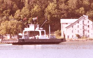
- M/V GLENORA, (for details see our database entry) ex-St. Joseph Islander, entered service between Glenora and Adolphustown in the spring of 1974, originally built 1953 as a fifteen-car ferry and modified 1974 in dry dock in Kingston to carry twenty-one cars.
- M/V QUINTE LOYALIST, (for details see our database entry) was christened 23 July 1954, and as of 2025 was still in service.
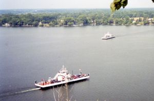
Currently (2025) Quinte Loyalist and Glenora operate carrying 21 cars; the length of the car decks is approximately 38.7 metres (127 feet), with a height restriction of 4.1 metres (13 feet 5 inches) and a maximum gross load of 18 tonnes.
Glenora
Youngs Point, Adolphustown, 44° 03' N, 77° 03' W is the mainland ferry terminal with three docks (the old eastern-most one in ruins). The working docks have elevations of 8 feet with a reported depths of 5 feet. The southern terminal of the ferry is at Glenora where the Ministry of Natural Resources Glenora Fisheries Station is located just east of the ferry dock. The wharves themselves are 5 feet high with a depth of 8 feet (under reconstruction 2003). The Canadian Hydrographic Service maintains a Benchmark at the ferry terminal 44° 2' 30"N and 77° 3' 36"W at an elevation of 76.056 metres. Previously (historically) described as "A G.S.C. bronze tablet stamped 67-U-163 set vertically in a concrete wall at the northwest side of the more easterly of two ramps for the ferry on the southwest side of Adolphus Reach on Hwy. 33. It is 9.0 km northeast of post office, tablet in top of wall, 30 cm from northeast end, 30 cm from southeast face, 5.5 metres northeast of gate at southwest end of wall, 53 cm below deck level of wharf."
Bay of Quinte Ferries.
At the extreme southwesterly point of Adolphustown, the Bay of Quinté is quite narrow, and from the point across to the Stone Mills, built by Major VanAlstine in Marysburgh, and the Lake on the Mountain, just above the mills, a ferry has been maintained from the earliest times, or since the mills were built. Below the point, toward Glen Island and Kingston, the Bay is known as the Adolphustown Reach. From Picton eastward along the Sophiasburgh shore, extending beyond Green Point toward Deseronto, – a stretch of about twenty miles, the Bay gets the name of the Long Reach.
Likewise, between Thompson's Point and Nicholas Wessel's farm on the Sophiasburgh shore, in the early years, a ferry was maintained for some time called Wessel's Ferry. The roadway up the long steep hill from the landing terminated in a spacious lawn, about an acre in extent, on which at one time stood a handsome frame church, painted white, capable of holding about four hundred people, and known as Wessel's Church, of the Methodist Episcopal denomination. Among certain money grants to Sophiasburgh in 1820, it is on record that a grant of $100 was appropriated toward opening a road from Wessel's Ferry through to Demorestville Mills. A quarterly communion service held in 1844, attended by an unusually large congregation, when the Rev. George Jones preached a sermon from that well-known text in which Job's wife offers her husband a peculiar, if not sarcastic, word of consolation, was about the last gathering held in the historic Wessel's Church, which has since been dismantled and torn down, leaving neither stick nor stone, and not even a trace of the foundation. It is just a grassy plain flanked by a beautiful grove; nought else remains to show that a sacred edifice had once stood on the deserted plain.
About a mile farther east on the same shore is Scanlon's Ferry, for years maintained to cross at the junction of Hay Bay and the Long Reach. At the landing was a commodious warehouse, while the roadway up the steep bank terminated in Scanlon's general store on the brow of the hill, where a considerable country trade was transacted in the early days. The erection of the warehouse at the landing, the foundations of which extended partly over the water, furnished a drama of considerable interest to the community for a long period afterward. I often heard my father and my grandfather describe the incident. They were present at the "raising," with a large concourse of men, and among them was a character known as "Devil" Tom Dorland. He was not really a bad man, but had a reputation for doing eccentric and risky tricks. When the men had raised the outer heavy plate to its position on the main posts, it was found to be wrong end on, and had to be turned. The plate was balanced on the centre post preparatory to being swung, when "Devil" Torn insisted on getting astride one end of the big plate, and in that perilous position, sixty feet above the water, he swung around with the plate to the consternation of the crowd. The warehouse has long been dismantled, and every vestige of it has vanished. Not a stone of the foundation remains to show its former site. Portions of the masonry which formed the artificial roadway up the steep bank have become disintegrated, and are rapidly crumbling away and sliding down the embankment.
Another ferry, half a mile farther east, was Hazzard's Ferry, maintained intermittently across the Long Reach to the Hay Bay shore. Here also was Hazzard's sawmill, worked by a somewhat puny water power.
One and a half miles still farther east is "Princess Sophia's Ravine," or Roblin's Ferry, crossing the Long Reach to Casey's Point, and maintained since 1817.
Two miles farther east, on Lot No. 43, is Clark's Ferry, or Clark's Crossing, originally known as "Job Bower's Ferry and Potashery Works," maintained since 1785. It was called Clark's Ferry after a family of that name, living on the Adolphustown side. It was long known as Bedford's Ferry, from a man who kept a store on the Sophiasburgh side. Bedford moved to Belleville, and was succeeded by Munroe, when for some time it was called Munroe's Ferry. Of late years it has been known as Cole's Ferry.
[ Early Glenora ferries ] [Bibliography ]